
Qula
Ruins of a Crusader fortress, later a khan and Arab village

Qula Crusader Fortress sits in the Qula national forest south of El’ad and Rosh Ha-Ayin, at the Giv’at Ko’ach junction east of the moshav (cooperative agricultural settlement) of that name. The Mazor Mausoleum—which we visited the same day—is just north of the forest.
Giv’at Ko’ach has the double meaning of 'Hill of the Twenty Eight' and ‘Hill of Strength,’ being named—at its founding in 1950 by immigrants from Yemen—for the 28 soldiers (כ"ח is the Hebrew numerals for 28) from the Alexandroni Brigade who died in fighting at Qula during the 1948 Arab-Israeli War. A monument to these soldiers is located on a hill about 3 km east of the village. We shall return to hear about this fight later.
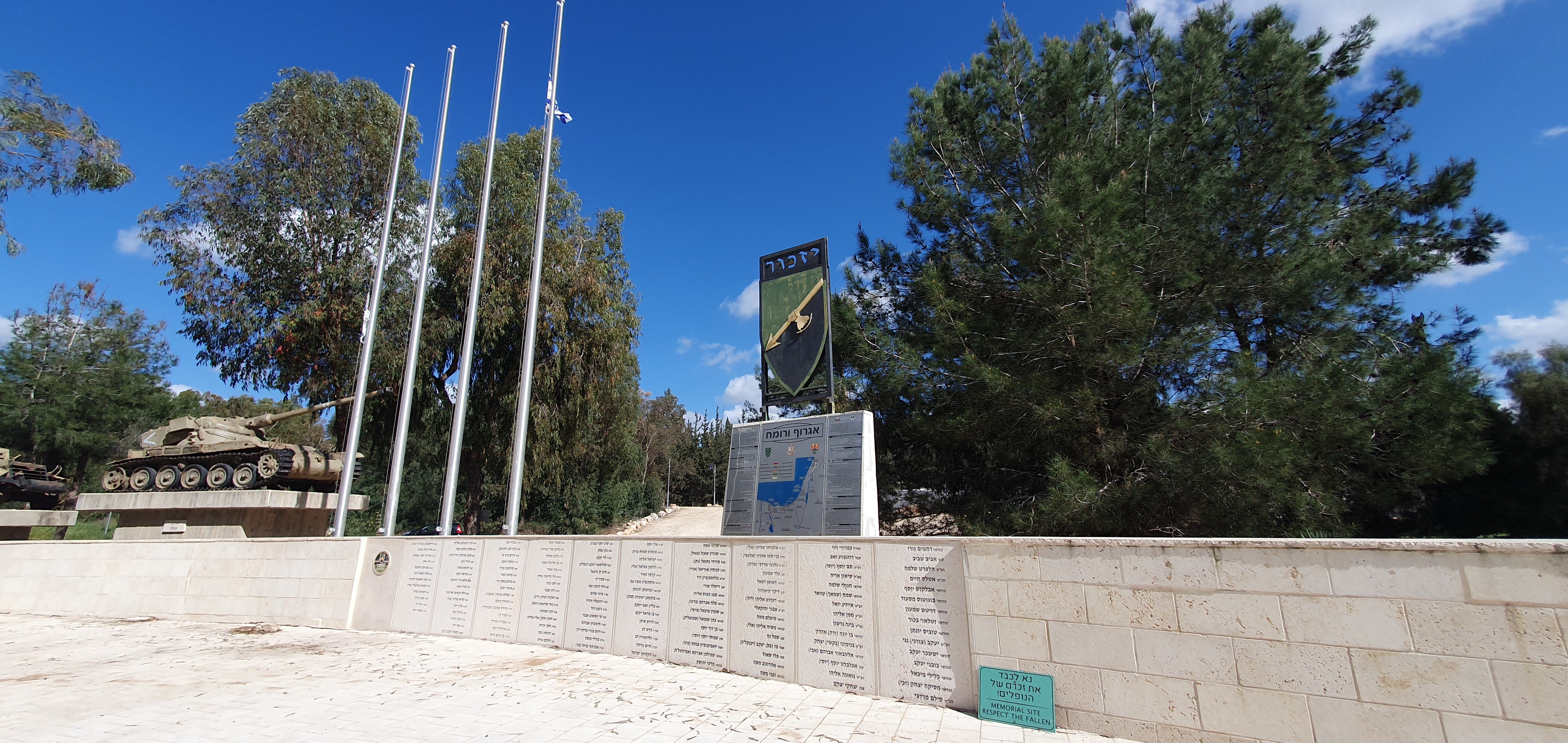
However we didn’t visit this monument, but another at the Giv’at Ko’ach junction: the The Egrof Varomach ("Fist & Lance") memorial, which honours the 147 fallen soldiers of the brigade of that name, established in 1952 as the 27th Brigade, the IDF’s first reserve armored brigade.
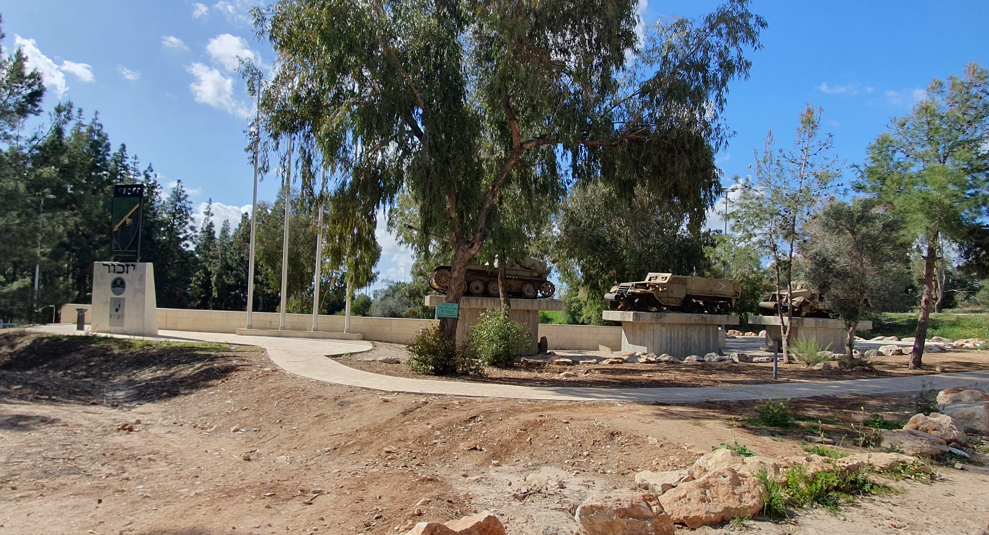
The Egrof Varomach Brigade saw action in the Sinai War, the Six-Day War and War of Attrition (as the 60th Brigade), and the Yom Kippur War and the 1982 Lebanon War (as the 264th Brigade), before its dissolution in 2014. The monument was originally erected in the Sinai desert near Refidim but, when Israel evacuated the Sinai following the peace treaty with Egypt in 1980, the monument was moved to its current location, and it was last renovated in 2018. The site features a large plaza with seating and a path adorned with the brigade’s badge. It displays two half-tracks and an AMX-13 tank damaged during the Six-Day War. Information about the brigade is available in Hebrew and English.
From the monument we proceeded to the Qula forest, and began walking towards the ruins.
The American biblical scholar, Edward Robinson, noted that the Arab village of Qula could be seen from the top of the White Mosque at Ramla. Surveys conducted at the site in the nineteenth century (in 1870, by Victor Guérin, the French intellectual, explorer and amateur archaeologist, in 1875 and by Conder and Kitchener, in 1873, for the Palestine Exploration Fund) documented a water-storage pool in the center of the village and buildings erected on ancient remains that probably dated from the Crusader period. An Ottoman village list from 1870 showed Kula with a population of 159 men and 38 houses.
Guérin wrote, in volume 2 of his Description Géographique Historique et Archéologique de la Palestine (1875):—
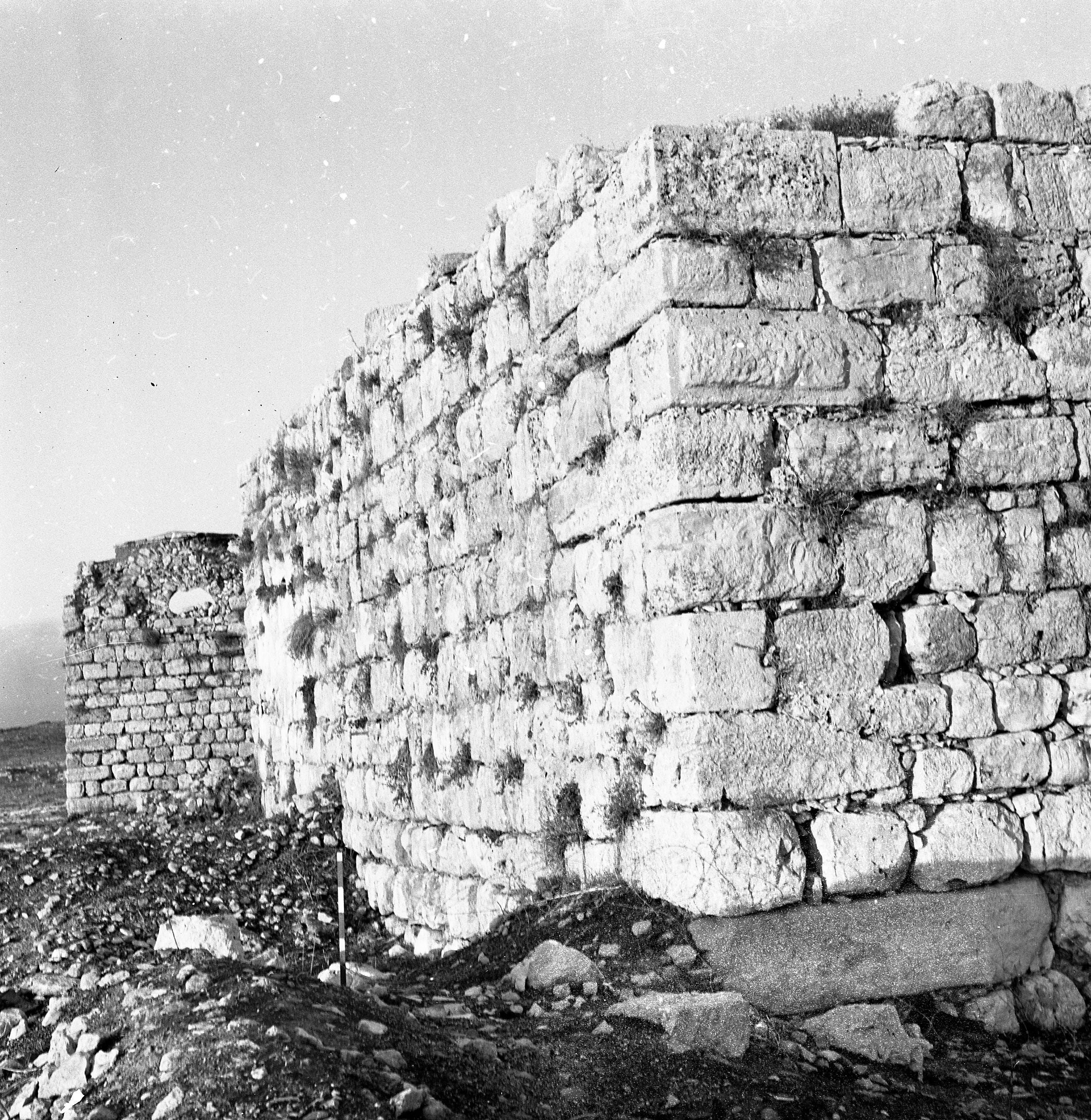
This village, located on a rocky hill, obviously replaced a small town or ancient village. There is a large building now divided into several private dwellings, built either by the Muslims or by the Christians at the time of the Crusades, with cut stones removed from old buildings. Besides, there is another construction, less extensive than the preceding one, but the lower courses of which are formed with much larger blocks, either flattened or cut into bosses, still serving at present as a tower, or defense tower. All the upper part is of a much more recent date. A small mosque is similarly built with materials of which at least half seem ancient. At the door in particular of this sanctuary the feet are decorated with moldings that seem to be pointing to a time before the Muslim invasion. Finally, near the village, a birket [pond], 18 paces by 12 wide, is probably not the work of the Arabs. It is partly dug in the rock and partly constructed of large polygonal blocks coated with thick cement.
Conder and Kitchener write of visiting Qula on June 7th, 1873, in their 1882 Samaria volume of the Survey of Western Palestine:—
This village includes some well-built structures. There is a large building of small well-cut masonry of mediaeval appearance; the door on the south has a pointed arch and a tunnel vaulting. South of this is a square building, with walls 10 feet to 12 feet thick, and a staircase on one side leading to the roof ; the corner stones are large, drafted, and with a rustic boss; there are remains of a lofty doorway. This is called Burj [tower or fort] Kûleh. There is a birkeh [pool], about 20 feet square, and 6 feet or 8 feet deep, lined with good cement ; it is called Birket er Ribba. These remains have the appearance of Crusading work, and the name, Neby Yahyah [John the Baptist], close by [at Mazor], points also to former Christian occupation of the place.
The village mosque stood approximately 10m east of the Crusader tower. It comprised a large vaulted iwan [a vaulted, open-ended hall] and a smaller room with an inscription above the entrance. It no longer stands.
Two surveys conducted in the region during the twentieth century were the first to document the agricultural area beyond the boundaries of the Late Ottoman village, where there are cisterns, shafts, tombs, winepresses, and agricultural installations. In 1996, during a salvage excavation, a hoard of silver antoniniani and aurelianiani was discovered. Antoniniani are coins used during the Roman Empire, introduced by Caracalla in early 215 CE, thought to have been valued at 2 denarii. Initially made of silver, they were gradually debased to bronze with a minimal silver content, known as billon. Aurelianiani are silver-plated bronze or copper coins with a thin wash of silver.
The hoard of 2,019 billon was found in a room in the northern part of a structure identified as a farmhouse and dated to the Roman, Byzantine and Umayyad periods (third–eighth centuries CE). The reasons for the concealment of the hoard remain unknown, but from the archaeological context it was likely buried in the early 290s CE, prior to the monetary reforms of Diocletian, when he established a new trimetallic system of gold, silver, and bronze coinage and attempted to curb inflation with various measures.
Excavations at the turn of the 21st century focused on the village’s western fringes and uncovered settlement remains dating from the Hellenistic, Roman, Byzantine, and Ottoman periods, although burial caves from the Chalcolithic period and the Early and Intermediate Bronze Ages have been found, as well as Roman and Byzantine tombs, with a lime kiln from the Byzantine–Early Islamic periods discovered near one of the burial complexes. A full survey of the area—which spanned both the roads meeting at Giv’at Ko’ach junction and route 6, which runs alongside—was carried out in 2008. Salvage and trial excavations near these roads, but away from the fortress, were carried out in 2010 and 2016.
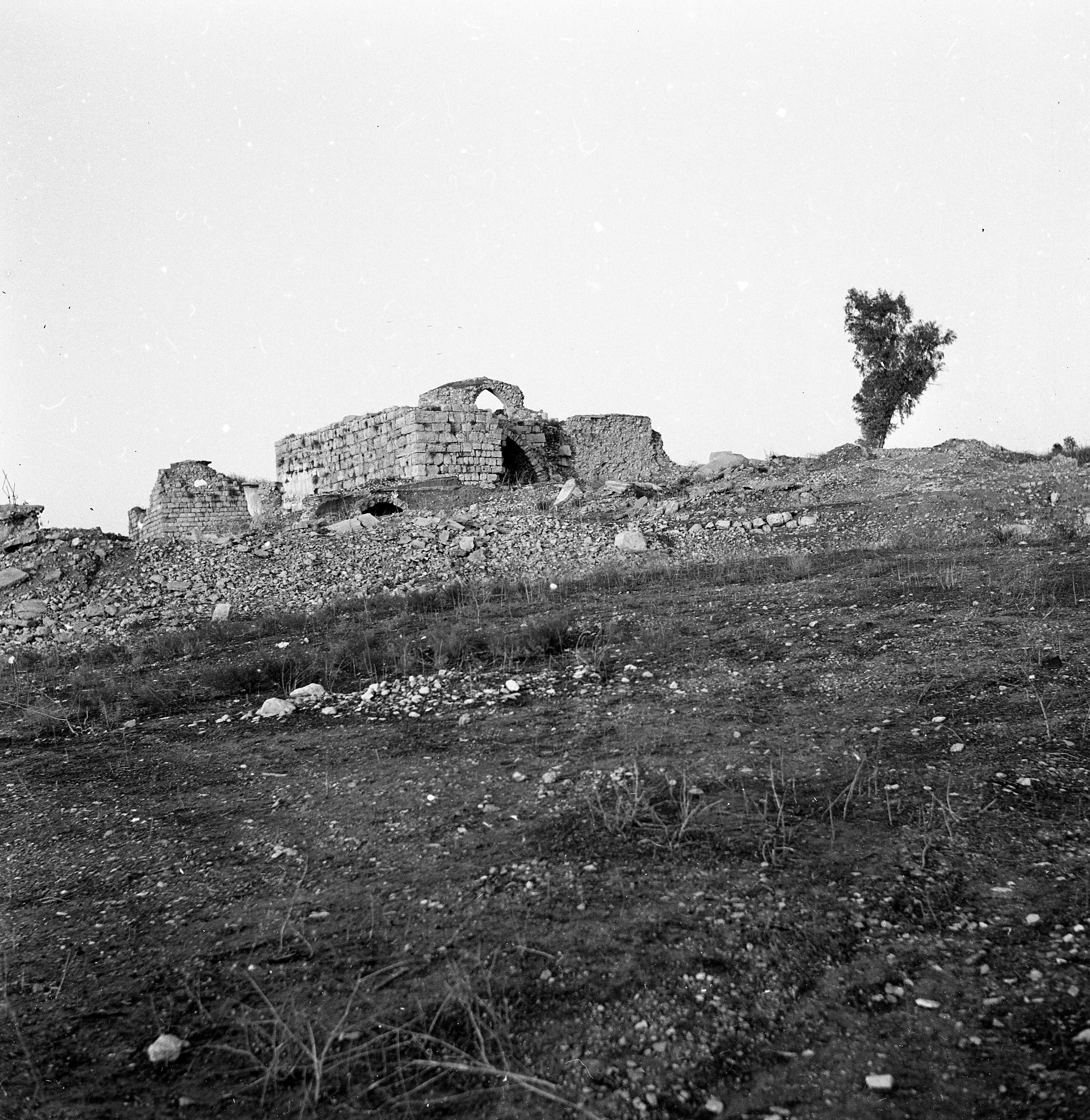
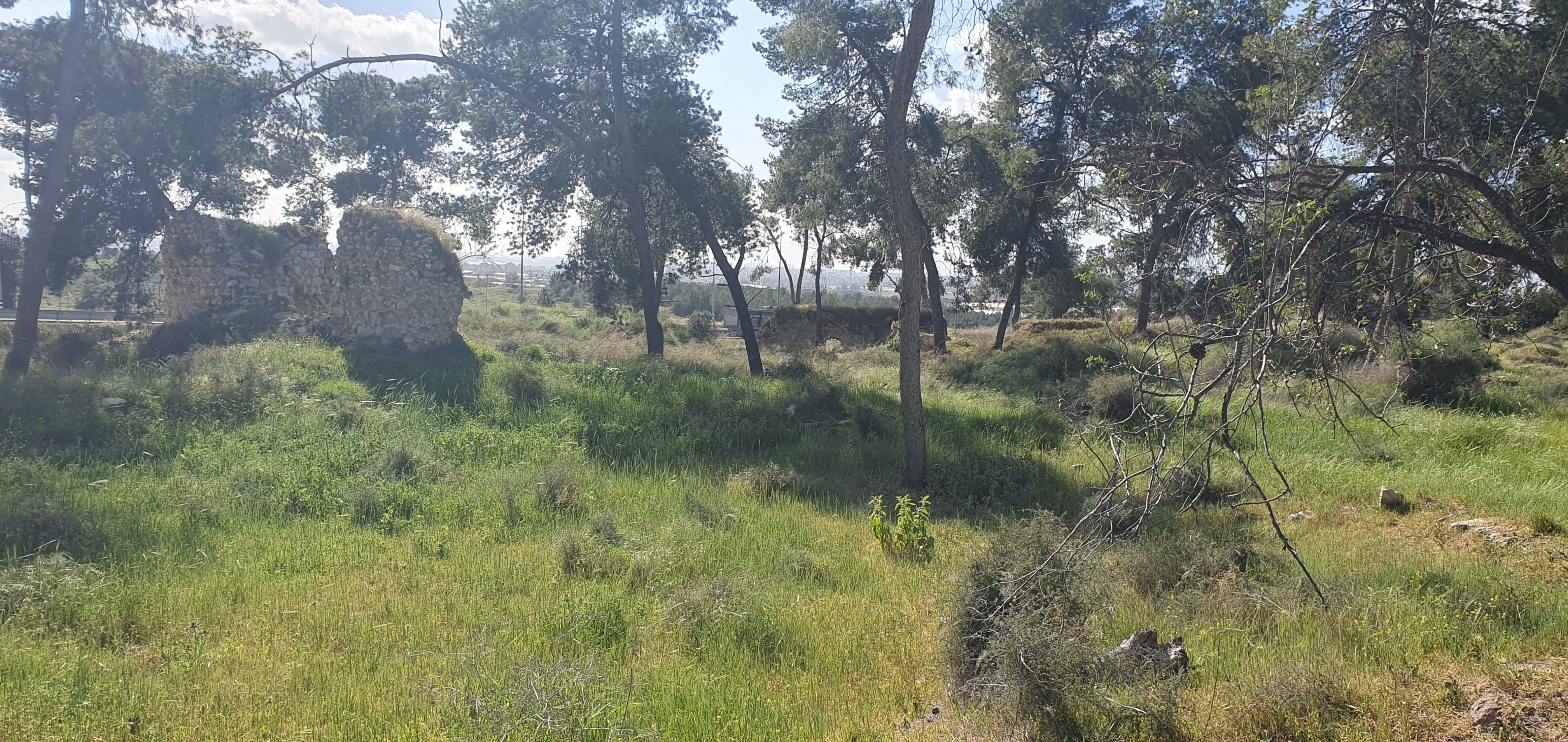
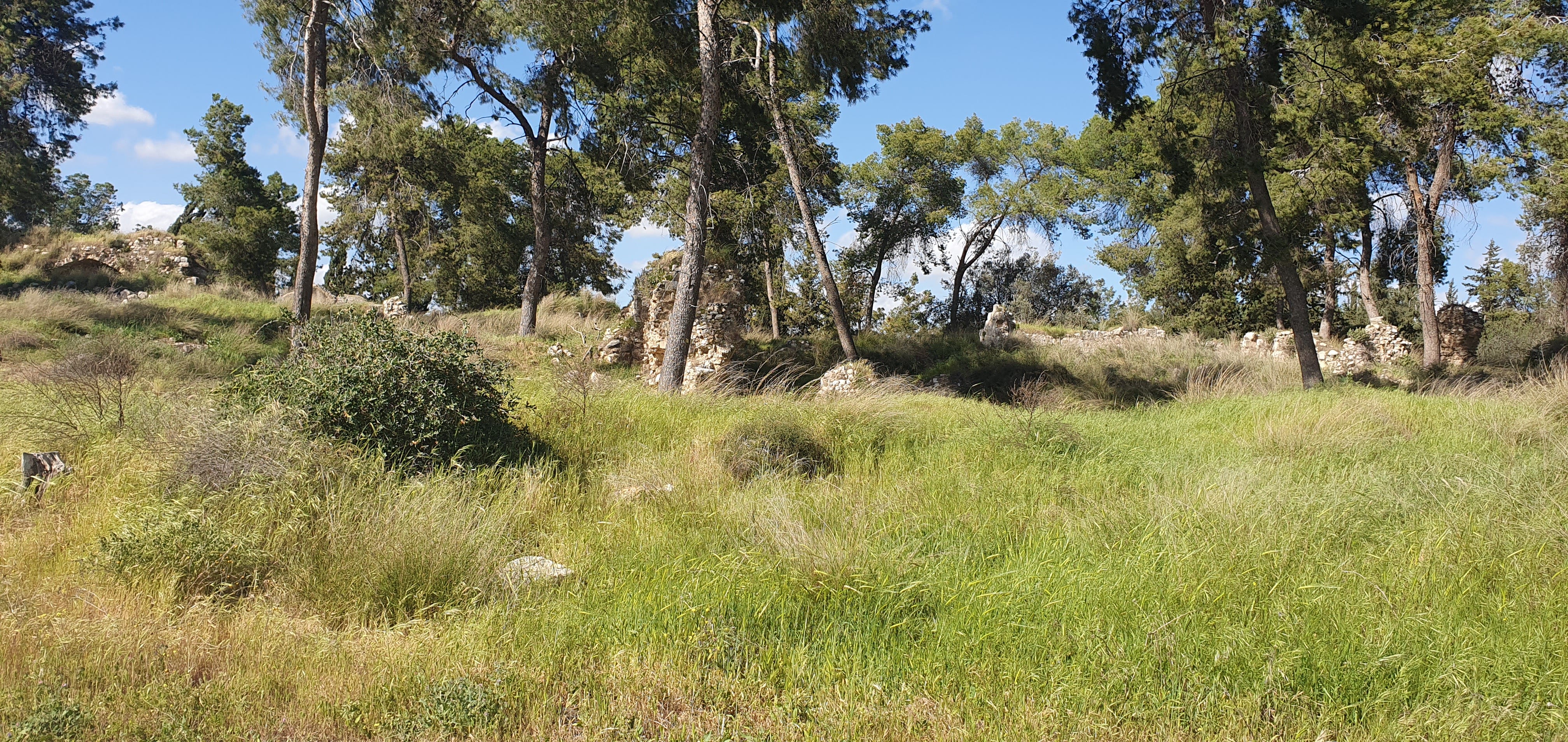
The Qula Fortress (the remains of whose keep is pictured below) was built around 1181 by the Knights Hospitallers of St. John as a central administration center in Qula, then named Kola or Cola. It comprised a vaulted structure and a tower, which acted as a relay station for fire signals, with a system of cisterns and wells to provide a water supply even during times of siege. It was destroyed by the Ayyubid invasion led by Saladin, 6 years later. During the third Crusade, Richard the Lionheart re-captured most of the coast line, Jerusalem and parts of the Galilee, and the truce agreements in 1198 and 1229 left the Qula area in the hands of the Crusaders as a station along the road to Jerusalem. However they were pushed back to the coastline areas in 1244-1254. Finally the Mamelukes pushed the Crusaders out around 1266, and the fortress of Qula was abandoned and destroyed.


Some time in the Ottoman period, the Arab village of Kûleh (قُولَة) was built on the highest hill, which today is covered by a forest. It was built over the earlier layers, reusing the Roman and Byzantine structures as foundations, and masonry as building materials. Many houses incorporated ancient cisterns and installations, and the Crusader fortress was turned into a Khan. The use of ancient settlement remains and their foundations by Arab villagers from the time of the British Mandate and before is a well-known phenomenon in archaeological research, documented at many sites. The Arabs often built the walls of their houses on top of ancient walls, and re-used cisterns and rock-hewn installations, as well as building stones. Openings of shafts and caves were mostly blocked up with fieldstones.
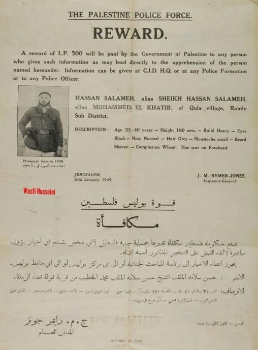
In 1931 there were about 172 houses and a population of 697, all Muslims. The Arab village existed until 1948. Qula was the birthplace, in 1913, of Hasan Salama, who participated in the 1933 Palestine riots, and wasa leader of the 1936–39 Arab revolt. He was injured in the battle of Ra's al-‘Ayn and died on 2 June 1948. His son, also born in Qula, was Ali Hasan Salama, Fatah commander of the Black September unit and the man chiefly responsible of the Munich massacre at the 1972 Olympics.
According to historian, Benny Morris, the 8th Brigade, assisted by the 33rd Battalion (Alexandroni) and the 44th Battalion (Kiryati) advanced southward and eastward to encircle Lydda (Lod) and Ramla and the rural hinterland to the east, as part of Operation Danny, first taking Qula, al-Tira and other villages on 10 July 1948. A bloody ‘seesaw battle’ between the Alexandroni Battalion and the Arab Legion’s First Brigade saw them take Qula for the final time on 18 July, just before the second truce came into effect. There they found the bodies of sixteen Alexandroni troopers left behind when the Legion had taken the position last on 16 July. An Israeli investigatory report found that “On most of them were signs of severe mutilation: stab wounds, some had their genitals cut off, some were missing ears. One body was cut into many bits with its genitalia stuffed in its mouth. Without doubt some of the dead fell into Arab hands while alive and were killed subsequently…Their trousers [and] shoes were missing.” Plus ça change…
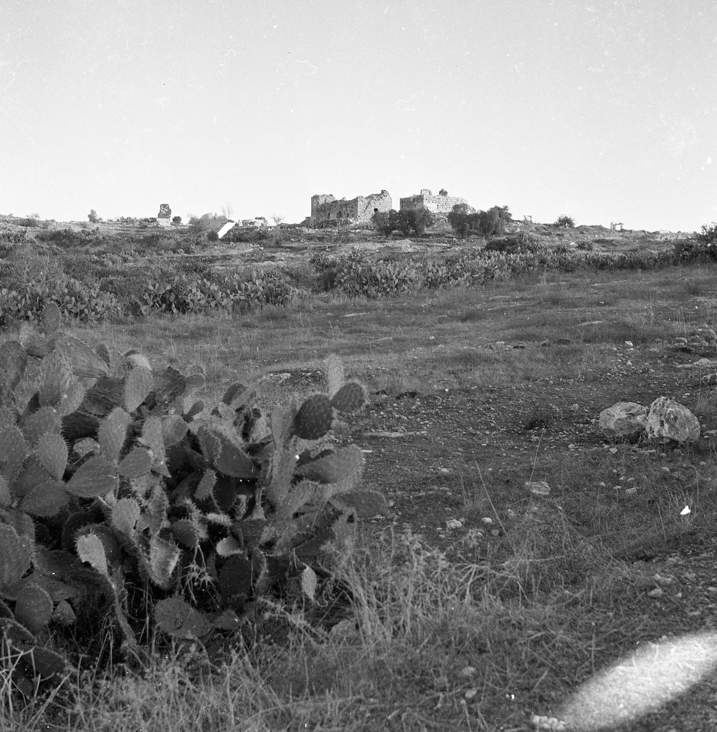
The village was destroyed during and after the war, and only remains of the fortress and bases of some structures can be seen today.